Google Integrates Gemini AI with Maps Data for Real-Time Location Insights
Google's Gemini AI Gains Real-Time Access to 250 Million Map Locations
Google has launched "Grounding with Google Maps," a significant upgrade to its Gemini API that deeply integrates artificial intelligence with the company's vast geographic database. The new feature allows Gemini models to directly access structured information from over 250 million locations worldwide, including addresses, operating hours, user reviews, and photos.
How It Works
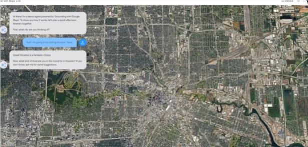
When users submit queries related to locations, businesses, or travel routes, Gemini now automatically identifies the intent and pulls real-time data from Google Maps to generate responses. For example:
- "Coffee shops near me suitable for remote work" returns recommendations with Wi-Fi availability ratings
- "Weekend parks for children" generates suggestions filtered by nearby amenities and weather conditions
The system enhances responses with visual map components, combining operational data with practical navigation information.
Technical Implementation
The tool supports multiple Gemini models including:
- Gemini 2.5 Pro
- Gemini 2.5 Flash
- Gemini 2.0 Flash
Developers can activate the functionality by enabling the "googleMaps" tool in API requests, accessible through Python SDK or Google AI Studio. The integration provides context tokens that allow embedding interactive map components directly in application responses.
Addressing AI Limitations
The massive dataset—which includes historical traffic patterns, real-time updates, and user-generated content—helps mitigate the common problem of AI hallucinations in location-based queries. Previous systems might generate non-existent addresses or outdated information, while the new integration ensures responses are grounded in verified map data.
Industry Applications
The technology has broad implications across sectors:
- Real estate: Automated neighborhood facility reports
- Retail: Location-based inventory and promotion alerts
- Logistics: Dynamic route optimization avoiding traffic congestion
- Tourism: Comprehensive itinerary planning with attraction details
The feature works particularly well when combined with Google Search grounding, creating a powerful hybrid of structured geographic data and dynamic web information.
Availability and Considerations
The service launched globally across:
- 200+ countries/regions
- 36+ supported languages
However, the deep integration raises important considerations about:
- Data accuracy responsibility for business information
- Privacy implications of combining query history with location data
- Market competition impacts as Google strengthens its mapping-AI dominance
The move represents a strategic play by Google to combine its core mapping assets with emerging AI capabilities, potentially setting new standards for location intelligence applications.
Key Points:
- Direct access to 250M+ verified locations via API
- Reduces AI hallucinations in geographic responses
- Supports multimodal interactions (voice + maps)
- Available now for developers worldwide
- Raises questions about data accuracy responsibility
